
Walk an Elkhart Street by Address
A street-wide search should begin with one verified situs address. Situs means the physical place of the parcel, while the mailing address is where assessment notices go. The two may differ. Work outward from the first parcel in a fixed direction and date every result. That produces a repeatable Elkhart street directory sequence without turning an assessed owner into an unsupported claim about occupancy.
- Confirm the address spelling and suffix, then search the Beacon property map. Save the parcel number, situs, owner mailing line, and legal description.
- Open the map and click the next parcel along the block. Record each polygon in order, including rear lots or parcels with more than one situs.
- Use the current owner and transfer line to enter the Recorder's land-record path. Classify each deed or lien by document type.
- Check one named person through Indiana Voters when appropriate. It is an exact name, birth date, and county check, not a browseable street roll.
- For older occupants, consult dated criss-cross directories, census schedules, newspapers, and maps. A historical entry proves only what that edition recorded.
The flow is address to parcel, parcel to owner, owner to deed, and dated occupant evidence last. Keep the legal description when a street name or house number changes. It is often the most durable bridge.
Elkhart Street Directory Search Fields
The Elkhart County assessor search guide documents three direct routes. Address is best for a street directory, owner finds parcels tied to a name anywhere in the county, and parcel number stabilizes later work. The guide has one unusual detail: a parcel-number search must include 20. Do not rebuild a number from memory.
| Control | Input | Best use | Verified note |
|---|---|---|---|
| Owner | Text/autocomplete | Find assessed parcels by name | Try initials and spelling variants |
| Address | Text/autocomplete | Find the physical situs | Select the right match before mapping |
| Parcel Number | Text | Return to one stable parcel | County guide says include 20 |
| View Map | Button/link | Place parcels in street order | Click the parcel for its card |
| Property Record Card | PDF link | Save the dated record | Field visibility varies by year |
The official assessor GIS page shows this workflow in context.
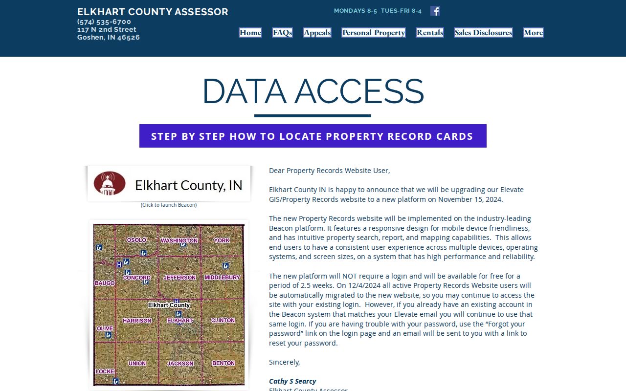
The captured page points from the assessor to the map and record-card route used for each Elkhart street parcel.
Address Records Across Elkhart Streets
No single custodian maintains a full household list. The Elkhart street directory method instead joins records that answer different questions. The parcel number connects the assessor, tax, map, and deed layers. Street spelling connects permits and older directories, but it can be less stable.
| Address source | Keeper | What it establishes | Access channel |
|---|---|---|---|
| Property card | County Assessor | Owner, mailing and situs addresses, parcel, legal description, assessment and transfers | Beacon PDF or assessor counter |
| Parcel geometry | County GIS | Map position and neighboring parcels | Beacon or official ArcGIS viewer |
| Deeds and plats | County Recorder | Instrument parties, legal interest and boundaries | Tapestry, Laredo, public computer, copy request |
| Tax account | County Treasurer | Parcel account, year, billed and payment status | InvoiceCloud, phone or counter |
| Permits and code files | City Permit Center | Public work, application and inspection evidence | Counter or focused APRA request |
| Historic occupants | Libraries and archives | Dated directory or census address | Print, microfilm and licensed databases |
The Treasurer can support a parcel check, but the payer is not automatically the owner or resident. Likewise, a homestead field is an assessment clue, not final proof of who was present.
A practical street worksheet should give every parcel its own row. Useful columns are street number, directional prefix, suffix, unit, situs, parcel number, assessed owner, mailing-address difference, legal description, map date, latest transfer date, and unresolved question. Keep blank fields blank. If the map shows a vacant tract, public building, alley parcel, railroad strip, or river lot, describe that land use instead of forcing a person into the row. The same rule applies when one owner name covers several parcels. Shared ownership does not prove a shared household or family link.
Dates control the comparison. The assessor card can change after a sale or yearly assessment update. The deed has both an instrument date and a recording date. A directory reflects its publication cycle, and a voter result reflects a registration record checked at that moment. Place those dates beside the names. If the current owner has not yet appeared on a parcel card, compare the deed recording date with the card's assessment year before calling the records inconsistent.
Note: Elkhart is not the county seat, so core deed, assessment, tax, court, and voter offices are in Goshen.
Four Elkhart Address Terms
Clear terms prevent the most common street-search errors. A record can link a person to land without showing that person lived there.
- Parcel
- A mapped unit of land with its own county identifier.
- Situs address
- The physical location assigned to the parcel, distinct from the owner's mailing address.
- Plat
- A recorded map that identifies subdivision lots, blocks, streets, and boundaries.
- Criss-cross directory
- A directory arranged by street or telephone number instead of only by surname.
A street directory worksheet should keep all four fields when available. This makes it easier to resolve a split parcel, an out-of-town mailing address, or a historical street entry.
Renamed Streets Break Elkhart Searches
Elkhart's official street-name table is essential for old address work. Lincoln Street south of the railroad and west of South Main became South Second Street in 1887. Vistula became East Jackson in 1889. Later examples include part of Twenty-First Street becoming Nappanee Street in 1940, Hickory becoming Dr. King Drive in 1984, and Nappanee Extension becoming John W. Weaver Parkway in 1993.
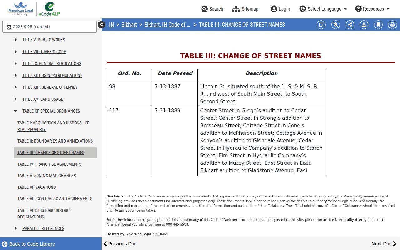
The ordinance table supplies the old name, new name, and date needed to test both forms in deeds, newspapers, and directories.
This local quirk explains why a sound by-address search may return nothing. Add a crosswalk with source year, old spelling, current spelling, addition or plat, and ordinance date. Then search both names while holding the legal description constant.
Elkhart Annexation Changes Address Context
City and county addresses do not share one numbering system. Elkhart's municipal chapter covers numbers on city streets, while unincorporated Elkhart County assigns five-digit numbers through its own system. A current city address may appear in an older source under a township, addition, rural route, or county-road label.
The city's annexation history runs from boundary action recorded in 1927 through additions in 2024.
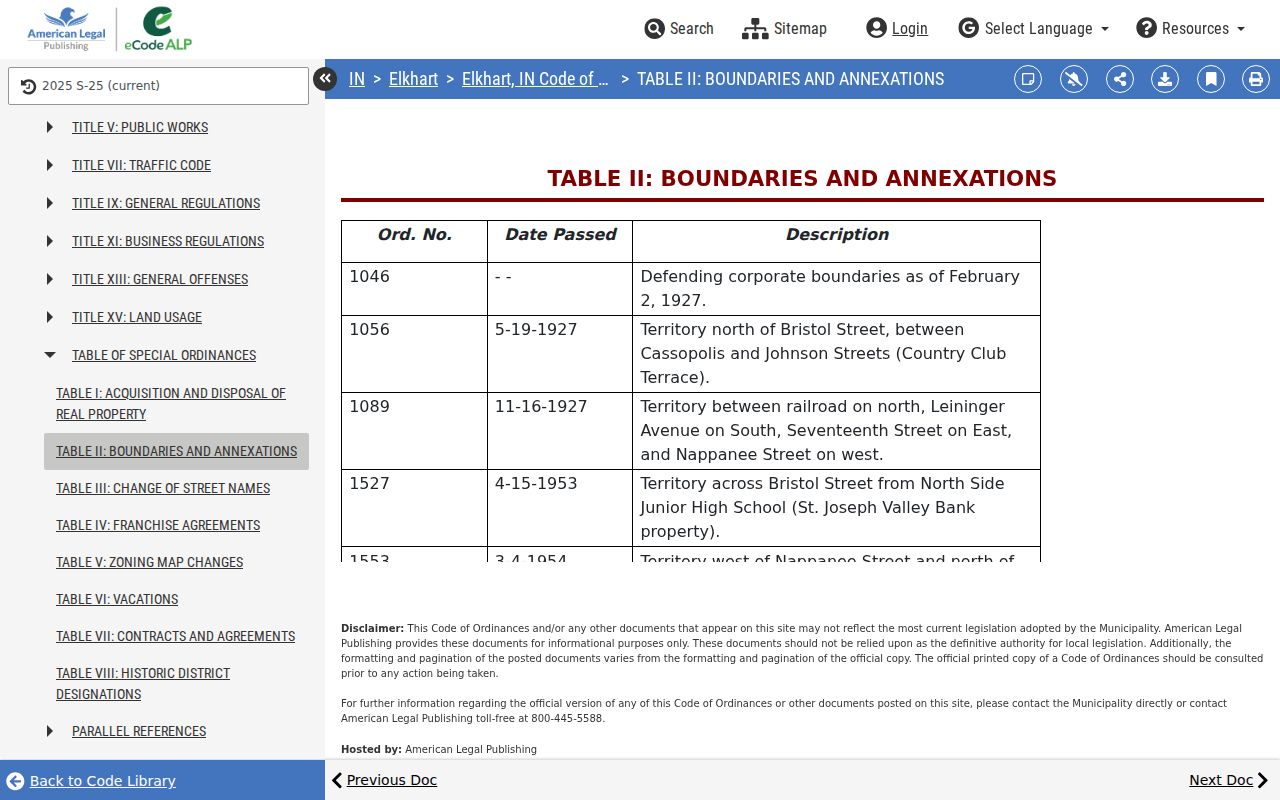
The dated table helps explain why the same land can sit in county records throughout its history while its municipal label changes.
Elkhart Street Records Since 1830
Elkhart County was formed on April 1, 1830, and its earliest deed material begins with that county era. The original county seat was Dunlap before the seat moved to Goshen. This history explains two practical facts. A search for an Elkhart city address often requires a trip through county systems in Goshen, and an early land search may use a township, addition, plat, or legal description rather than a modern city street. The Recorder describes land records as permanent public records, but permanence does not mean every index image is available through one current website.
FamilySearch catalog coverage reaches from 1830 through 1915. Later books and indexes also appear through State Library microfilm routes. The exact start of the current Tapestry online index has not been verified. When a modern by-address search stops, write down the last successful instrument, book and page, legal description, party roles, and prior reference. Those details provide a clean handoff to the public terminal or microfilm rather than forcing a new search from the street name alone.
The absence of a portal result is therefore an access gap, not proof that a parcel or person did not exist. No official evidence of a countywide deed loss was found in the Elkhart research. Move to the catalog, custodian, or a focused request before drawing a historical conclusion.
Railroad Growth Reshaped Elkhart Streets
The first train reached Elkhart on October 3, 1851. That date gives street researchers a useful local marker. Railroad growth and the later repair-shop era changed the city's industrial geography, while directories and Sanborn maps recorded new firms, streets, structures, and residential patterns at different intervals. A family that appears to move may instead be listed under a changed street name, a new house number, an addition name, or an occupation notation in a directory entry.
Test the idea with dates. Compare the deed's legal description with the nearest Sanborn sheet, then check directory editions on both sides of the suspected change. A newspaper citation can add a real-estate transaction or permit notice. Census schedules can show whether the household remained nearby. None of those sources should be made to say more than it records, but together they can explain why a name vanishes from one version of an Elkhart street directory and returns under another address form.
Elkhart Deeds and Permit Files
The Recorder's public records include deeds, mortgages, releases, affidavits, liens, plats, and other instruments. Tapestry offers a search and paid images, Laredo serves subscribers, and public computers provide the office alternative. The county does not publish a verified current online start year. When the portal fails, request a known document number or use the terminal rather than asking staff to perform an open-ended title search.
For construction history, use the Elkhart Permit Center. No complete public historical address index was confirmed. A focused Indiana Access to Public Records Act request should name the exact address or parcel, record class, and date range. Ask for an existing application, inspection history, certificate, or code order. That is more precise than asking for every record about a person.
Recorder copies cost according to the county's posted fee schedule, including $1 per page up to 11 by 17 inches and $5 for certification. Confirm the current charge before ordering.
Access does not end at the web portal. The Recorder's public computers are the main fallback for an index search, while a known recording number supports a phone, mail, or counter copy request. The Assessor can help with a parcel card at its Goshen office. Treasurer staff can check a parcel and tax year by phone or at the counter. For material that predates the live systems, Elkhart Public Library, Goshen Public Library, FamilySearch, Indiana State Library microfilm, and the county genealogical society provide separate historical paths. Each request should name the precise record and time span so the custodian can identify an existing item.
Historic Elkhart Streets by Directory
Criss-cross directories and street sections can supply a dated occupant between deed transfers. They should be paired with census, obituary, probate, or recorded evidence because editions omit people and may lag a move. Full collection details belong on the Elkhart city directory page; the street-level task is to match one address form to one edition.
The Indiana State Library's property research guide links directories with Sanborn maps, county histories, atlases, and newspapers.
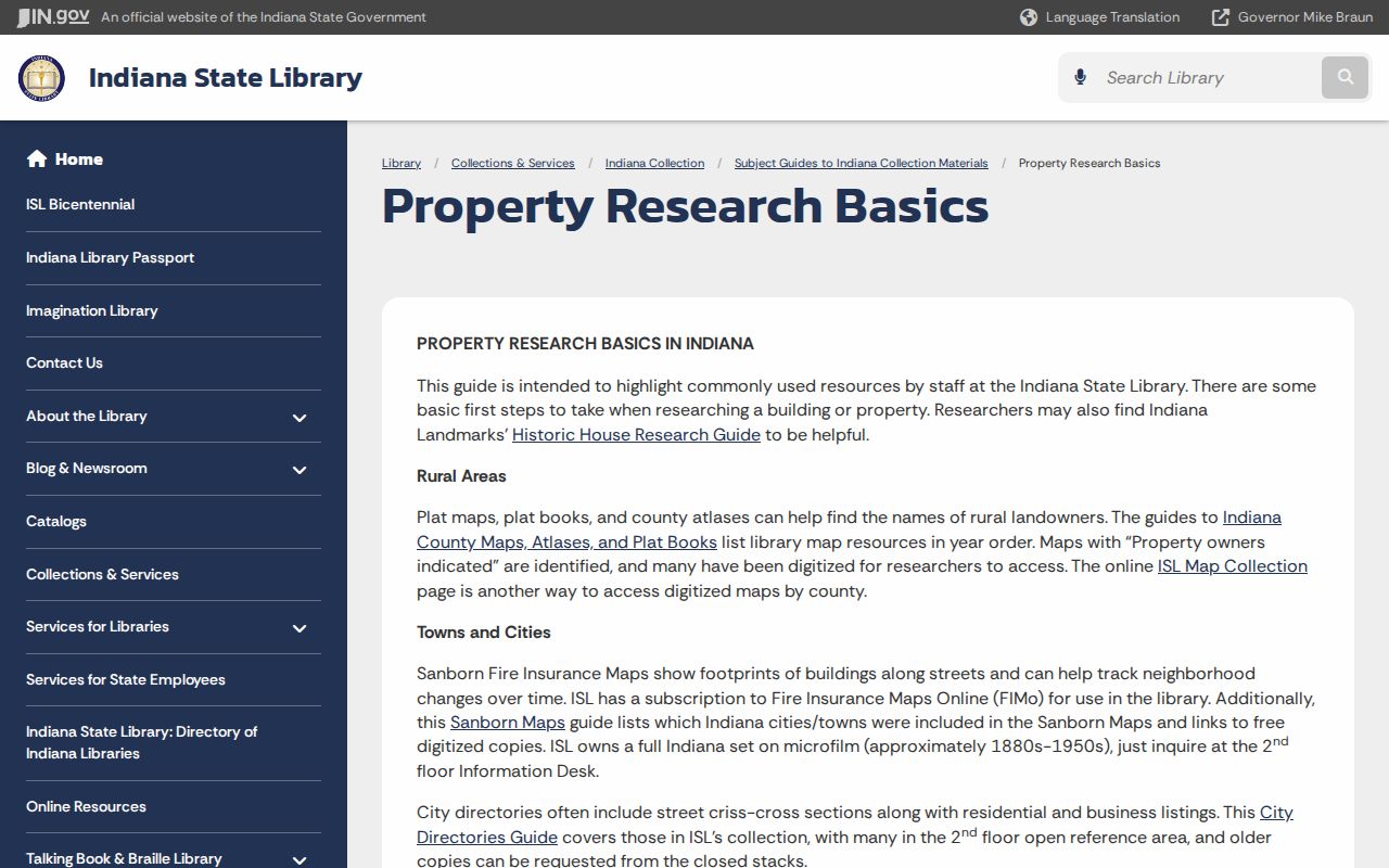
That mix can distinguish a named resident from the physical history of an Elkhart building.
Elkhart Streets and Civic Geography
A neighborhood name can add context, but it does not prove association membership or residence. The city's neighborhood association page names six groups and provides a public contact route. It does not publish a household roster.
The city page is useful for civic geography and outreach, while parcel and deed sources remain the evidence for land relationships.
A street directory entry should therefore separate postal city, incorporated city, subdivision, township, and neighborhood label. Each describes a different layer of place.
Limits of an Elkhart Street Directory
An Elkhart street directory cannot identify everyone inside a home. The assessor indexes owners and assessment parties. A deed records parties to an instrument. The Indiana voter portal confirms one exact registration and does not browse a street. Private utility, delivery, and motor-vehicle address data are not open household lists. Protected voters and Address Confidentiality Program participants may also be hidden.
Record only what each source proves. “This card links this owner to this parcel on this date” is sound. “Everyone at this address lives here now” is not. For the full named-street sequence, keep source dates, parcel IDs, and unresolved fields instead of filling gaps with commercial compilations.
Lawful use. Use Elkhart address records for personal research, property history, and civic curiosity. Never use them to stalk, harass, intimidate, or harm anyone.